Go Popular Tags

Posts

Let our community keep you entertained with regular articles that they would like to share with you.

Search our posts by passion or by type of post to find what you are looking for.

Elliott Brown Rivers, lakes & canals
30 Jul 2023 - Elliott Brown
Gallery

Soho Loop walk on the BCN Old Mainline

I was going to get onto the Soho Loop at Winson Green Junction, but on the BCN Mainline near Winson Green Road, towpath was closed, so walked down and got on at Rotton Park Junction. Then a minor diversion at the Soho Wharf development before rejoining at Spring Hill. Stayed on the Soho Loop until the Asylum Bridge (although would have gone further). But exited to Norman Street Park.

View feature View community

Soho Loop walk on the BCN Old Mainline


I was going to get onto the Soho Loop at Winson Green Junction, but on the BCN Mainline near Winson Green Road, towpath was closed, so walked down and got on at Rotton Park Junction. Then a minor diversion at the Soho Wharf development before rejoining at Spring Hill. Stayed on the Soho Loop until the Asylum Bridge (although would have gone further). But exited to Norman Street Park.


The Soho Loop opened in 1772, and was part of the Birmingham Canal Navigations Old Mainline and developed by James Brindley. It became a loop when the straighter Birmingham Canal Navigations Mainline, developed by Thomas Telford, opened in 1827. This created two junctions: Rotton Park Junction with the Soho Loop, Icknield Port Loop and the BCN Mainline and Winson Green Junction.


This walk was on Sunday 23rd July 2023.


Rotton Park Junction

Having caught the 11C bus to Summerfield Park, Winson Green, my plans changed when I found the towpath closed at the Winson Green Bridge, so couldn't walk to Winson Green Junction, so instead walked down the BCN Mainline and crossed the Rotton Park Towpath Bridge a Rotton Park Junction to get onto the Soho Loop. Here the skyline has changed, with The Mercian, The Bank towers 1 & 2 and the Cortland Square development on Broad Street. Icknield Port Loop to the right.

dndimg alt="Soho Loop" dndsrc="../uploadedfiles/BCNML%20Winson%20Green%2023072023%20(8).jpg" style="width: 100%;" />


Rotton Park Railway Bridge

View from the new Soho Wharf Footbridge, is the Rotton Park Railway Bridge at Rotton Park Junction. It carries the Birmingham to Wolverhampton railway line. This photo would have been impossible until the new footbridge had been built.

dndimg alt="Soho Loop" dndsrc="../uploadedfiles/Soho%20Wharf%20Soho%20Loop%2023072023%20(10).JPG" style="width: 100%;" />


Soho Wharf Footbridge

Most of the new Soho Wharf development on the left is now open. Also a new footbridge has opened to Spring Hill Wharf. I did walk a bit beyond, but found the towpath to be closed to Spring Hill, so had to double back, and divert off the Soho Loop and Soho Wharf to Dudley Road and Spring Hill.

dndimg alt="Soho Wharf" dndsrc="../uploadedfiles/Soho%20Wharf%20Soho%20Loop%2023072023%20(1).jpg" style="width: 100%;" />


Soho Wharf to Spring Hill

While I did walk a bit of the towpath here, found it to be closed at the Spring Hill Bridge, so had to leave the canal at Soho Wharf over the new footbridge. Street art on the walls to the right.

dndimg alt="Soho Wharf" dndsrc="../uploadedfiles/Soho%20Wharf%20Soho%20Loop%2023072023%20(11).jpg" style="width: 100%;" />


Spring Hill Bridge

A look at the Spring Hill Bridge and Soho Wharf. The towpath on this side was closed. Hopefully it wont be too long before they reopen it to the public.

dndimg alt="Soho Loop" dndsrc="../uploadedfiles/Spring%20Hill%20Soho%20Loop%2023072023%20(2).JPG" style="width: 100%;" />


Spring Hill Pipe Bridge 

Rejoining the Soho Loop at Spring Hill, to walk towards the Black British History is British History sculpture, this was the first bridge back on the canal.

dndimg alt="Soho Loop" dndsrc="../uploadedfiles/Spring%20Hill%20Soho%20Loop%2023072023%20(1).JPG" style="width: 100%;" />


Towards Crabtree Lane

The Soho Loop from Spring Hill to Crabtree Lane. Passed several cyclists around here. Some parkland on the right.

dndimg alt="Soho Loop" dndsrc="../uploadedfiles/Hockley%20Soho%20Loop%2023072023%20(1).JPG" style="width: 100%;" />


Western Road Bridge

The Western Road Bridge carries Crabtree Lane.

dndimg alt="Soho Loop" dndsrc="../uploadedfiles/Hockley%20Soho%20Loop%2023072023%20(2).JPG" style="width: 100%;" />


Towards Hockley Port Junction

This long straight section towards Hockley Port Junction. Lots of trees here, feels very rural.

dndimg alt="Soho Loop" dndsrc="../uploadedfiles/Hockley%20Soho%20Loop%2023072023%20(3).JPG" style="width: 100%;" />


Soho Branch at Hockley Port Junction

The next bridge crosses over at Hockley Port Junction which leads to the Soho Branch and Hockley Port. Private, the gate looked locked, but could see narrowboats down there.

dndimg alt="Soho Loop" dndsrc="../uploadedfiles/Hockley%20Soho%20Loop%2023072023%20(4).JPG" style="width: 100%;" />


Curving round City Hospital

A curved section, City Hospital is on the left (behind the trees). Then had to walk past lots of fishermen!

dndimg alt="Soho Loop" dndsrc="../uploadedfiles/Hockley%20Soho%20Loop%2023072023%20(7).JPG" style="width: 100%;" />


The Wildlife Trusts Birmingham & Black Country

Still passing the fishermen, on the left was The Wildlife Trusts Birmingham & Black Country, part of the Centre of the Earth. Was a boat moored called 'London Poly Roger'.

dndimg alt="Soho Loop" dndsrc="../uploadedfiles/Poly%20Soho%20Loop%2023072023%20(3).JPG" style="width: 100%;" />


Black British History is British History

The reason for this Soho Loop walk was to find this steel sculpture by Luke Perry called 'Black British History is British History'. It was unveiled in 2023. Was also designed by artist Canaan Brown.

dndimg alt="Soho Loop" dndsrc="../uploadedfiles/Black%20BH%20is%20BH%20Soho%20Loop%2023072023%20(1).jpg" style="width: 100%;" />


Asylum Bridge

A look at the Asylum Bridge. Originally I would have walked past it, but I went up onto it to see if it was open (Google Maps said it was closed, I later tried to get Google Maps to change it). Anyway I ended up exiting the Soho Loop here into Norman Street Park.

dndimg alt="Soho Loop" dndsrc="../uploadedfiles/Asylum%20Soho%20Loop%2023072023%20(1).JPG" style="width: 100%;" />


Winson Green Bridge

The view from the Asylum Bridge to the Winson Green Bridge. Was so close to the end of the Soho Loop. That bridge ahead carries another section of Winson Green Road. So will need to go back in future to complete the section to Winson Green Junction.

dndimg alt="Soho Loop" dndsrc="../uploadedfiles/Asylum%20Soho%20Loop%2023072023%20(2).JPG" style="width: 100%;" />


Norman Street Park

There was an Asylum Bridge steel sculpture near the bridge in Norman Street Park. Also this gateway, and a street art wall. Ended up leaving here for the 11A bus stop on Aberdeen Street (not far from City Hospital).

dndimg alt="Soho Loop" dndsrc="../uploadedfiles/Norman%20St%20park%2023072023%20(4).jpg" style="width: 100%;" />


Nearby bus routes include the 11A, 11C, 82 and 87.

Appears to be in walking distance of Jewellery Quarter Station (trains) or Winson Green Outer Circle Tram Stop or Soho Benson Road Tram Stop (trams).


Photos by Elliott Brown

Share  Spend Points  Connect with us
80 passion points
Elliott Brown Rivers, lakes & canals
26 Jun 2023 - Elliott Brown
Gallery

Walk up the Tame Valley Canal from Tame Bridge Parkway towards Great Barr

I got the train to Tame Bridge Parkway Station in Sandwell, and had a walk in the hot weather along part of the Tame Valley Canal. This bit goes near the M5 and M6 motorways. I got off at the Newton Road Bridge in Great Barr (then tried to make my way to Hamstead for the next train to Birmingham). Was probably too hot and humid to do the walk.

View feature View community

Walk up the Tame Valley Canal from Tame Bridge Parkway towards Great Barr


I got the train to Tame Bridge Parkway Station in Sandwell, and had a walk in the hot weather along part of the Tame Valley Canal. This bit goes near the M5 and M6 motorways. I got off at the Newton Road Bridge in Great Barr (then tried to make my way to Hamstead for the next train to Birmingham). Was probably too hot and humid to do the walk.


After arriving at Tame Bridge Parkway Station on Saturday 24th June 2023, left the station via the entrance / exit on the Walsall Road, then headed onto Navigation Lane, to get onto the Tame Valley Canal.


Stonecross Bridge

The Stonecross Bridge, also called Friar Park Bridge or the Walsall Road Bridge. I did not walk in that direction, as was heading to a couple of aqueducts nearby.

dndimg alt="Tame Valley Canal" dndsrc="../uploadedfiles/TVC%20Tame%20Bridge%2024062023%20(3).JPG" style="width: 100%;" />


Navigation Lane Aqueduct

This aqueduct crosses over Navigation Lane, and is Grade II listed. Was built 1841-44.

dndimg alt="Tame Valley Canal" dndsrc="../uploadedfiles/TVC%20Tame%20Bridge%2024062023%20(4).jpg" style="width: 100%;" />


Grand Junction Aqueduct

This aqueduct is near Tame Bridge Parkway Station (opened in 1990). Was built over the Grand Junction Railway (now part of the Birmingham New Street via Perry Barr to Walsall line). Grade II listed, it opened in 1844. There is good views of the station from up here, as well as to the Bescot Yard, Bescot Stadium and The RAC building near the M6 motorway.

dndimg alt="Tame Valley Canal" dndsrc="../uploadedfiles/Grand%20Junction%20Aqueduct%20TVC%2024062023%20(2).jpg" style="width: 100%;" />


M5 Motorway Aqueduct

The next aqueduct crosses over the M5 motorway, to the north west, with it's junction with the M6. The River Tame is also near here, but didn't see it.

dndimg alt="Tame Valley Canal" dndsrc="../uploadedfiles/M5%20Aqueduct%20TVC%2024062023%20(3).jpg" style="width: 100%;" />


River Tame Aqueduct

One more aqueduct, this one crosses over the River Tame. Only had views of the M6 heading in this direction, or the Birmingham skyline and nearby tower blocks.

dndimg alt="Tame Valley Canal" dndsrc="../uploadedfiles/TVC%20aqueduct%20RT%2024062023.jpg" style="width: 100%;" />


Grey Heron

On the section of the Tame Valley Canal beyond the first M5 crossing, saw several grey herons.

dndimg alt="Tame Valley Canal" dndsrc="../uploadedfiles/Grey%20heron%20TVC%2024062023%20(3).JPG" style="width: 100%;" />


Rushall Junction

At this point on the Tame Valley Canal, is Rushall Junction where it joins onto the Rushall Canal. The Rushall Junction Bridge on the left.

dndimg alt="Tame Valley Canal" dndsrc="../uploadedfiles/Rushall%20Jcn%20TVC%2024062023%20(3).JPG" style="width: 100%;" />


Rushall Canal

The start of the Rushall Canal from the Rushall Junction Bridge on the Tame Valley Canal. Bridge in front carries the M6 motorway. Catshill Junction is about 8 miles and 9 locks away on this canal.

dndimg alt="Tame Valley Canal" dndsrc="../uploadedfiles/Rushall%20Canal%20Jcn%2024062023%20(1).JPG" style="width: 100%;" />


Brickfields Bridge

At this point, the towpath switches sides at the Brickfields Bridge. Behind is a pair of M5 motorway bridges, which go from the south west to north east, and join onto the M6. This footbridge is Grade II listed and dates to 1844.

dndimg alt="Tame Valley Canal" dndsrc="../uploadedfiles/M5%20Brickfields%20TVC%2024062023%20(4).JPG" style="width: 100%;" />


M5 Link Road Bridge 1

The first M5 link bridge can be seen from the Brickfields Bridge as you cross it, or as you walk or cycle under it. This is for traffic heading to the end of the M5 and onto the M6 going east.

dndimg alt="Tame Valley Canal" dndsrc="../uploadedfiles/M5%20Brickfields%20TVC%2024062023%20(3).JPG" style="width: 100%;" />


M5 Link Road Bridge 2

The second M5 link bridge. Seen after walking under it. This is for traffic leaving the M6 and heading onto the M5 motorway, heading south west.

dndimg alt="Tame Valley Canal" dndsrc="../uploadedfiles/M5%20Brickfields%20TVC%2024062023%20(5).JPG" style="width: 100%;" />


Brickfields Turnover Bridge

One more Victorian footbridge. Grade II listed, it dates to 1844. Formerly a road bridge apparently. Not sure where it went, but was a man fishing on the other side, and someone with their dog. The Brickfields Turnover Bridge probably links to nearby Chatsworth Avenue.

dndimg alt="Tame Valley Canal" dndsrc="../uploadedfiles/TVC%20Newton%20Rd%2024062023%20(1).JPG" style="width: 100%;" />


Newton Road Bridge

A very high (compared to the canal) road bridge on Newton Road in Great Barr. I took my exit here. Was very hot and sweaty by this point.

dndimg alt="Tame Valley Canal" dndsrc="../uploadedfiles/TVC%20Newton%20Rd%2024062023%20(5).JPG" style="width: 100%;" />


Could of continued to Hamstead and Perry Barr, but left at Great Barr, then tried to get to Hamstead on foot. But at one point caught a no 16 bus to the Scott Arms in Great Barr, before getting another 16 (probably the same one) to Hamstead Station.


In future, maybe best to do these canal walks in cooler weather. It was just too hot and warm. Plus there was the usual illegal off-road motorbikes I encountered on the canal. They were also on a path in a field that lead to Sandwell Valley.


Photography by Elliott Brown

Share  Spend Points  Connect with us
70 passion points
Elliott Brown Rivers, lakes & canals
25 Apr 2023 - Elliott Brown
Inspiration

Walking trail around Smethwick via Rolfe Street and Galton Bridge

Get the train up to Smethwick Rolfe Street or Smethwick Galton Bridge, for this wonderful walk around the area, via the BCN New Mainline and Smethwick High Street. There is plenty of heritage to see on your walk. From the Galton Bridge to the remains of Chance Glassworks.

View feature View community

Walking trail around Smethwick via Rolfe Street and Galton Bridge


Get the train up to Smethwick Rolfe Street or Smethwick Galton Bridge, for this wonderful walk around the area, via the BCN New Mainline and Smethwick High Street. There is plenty of heritage to see on your walk. From the Galton Bridge to the remains of Chance Glassworks.


Get the train from Birmingham New Street to Smethwick Rolfe Street, if starting near the Engine Arm Aqueduct. If you buy your tickets to Smethwick Galton Bridge, they should be valid for getting of at intermediate stations. 

From Smethwick Rolfe Street, walk up Rolfe Street to Bridge Street North, near the Smethwick Locks.

Engine Arm Aqueduct

The Engine Arm Aqueduct is near Rolfe Street in Smethwick. It starts at the junction of the Birmingham Canal Old Main Line, then crosses over the Birmingham Canal New Main Line. It was built in 1825 by Thomas Telford to carry a water feeder, the Engine Arm from Edgbaston Reservoir. It is Grade II* listed and a Scheduled Ancient Monument.

dndimg alt="Engine Arm Aqueduct" dndsrc="../uploadedfiles/4A6C52C8-0D94-4AB5-B681-81056BFB7F9D.jpeg" style="width: 100%;" />Photography by Jonathan Bostock


Leave the canal at the Brasshouse Lane Bridge, then walk down North Western Road to Rolfe Street.


Smethwick Rolfe Street Station

The railway station at Rolfe Street  in Smethwick, was opened in 1852 on the line between Birmingham New Street and Wolverhampton. It was rebuilt as it is now in 1890. A mural was painted at the station in 2017 under the direction of artist Steve Field. West Midlands Railway took over from processor London Midland in late 2017. Since 2022, the station has step free access.

dndimg alt="Smethwick Rolfe Street Station" dndsrc="../uploadedfiles/Smethwick%20Rolfe%20St%20(Nov%202017)%20(8).JPG" style="width: 100%;" />Photography by Elliott Brown


From Rolfe Street, cross the footbridge over Tollhouse Way, then head down High Street in Smethwick to the statue of a Sikh WW1 soldier.


Smethwick Cross Tollhouse

The tollhouse was built in 1820 on the Smethwick High Street. The road was part of the Birmingham, Wolverhampton and Dudley Turnpike 1760 - 1876. A Grade II listed building.

dndimg alt="Smethwick Cross Tollhouse" dndsrc="../uploadedfiles/Smethwick%20CT%20(Jun%202012)%20(1).JPG" style="width: 100%;" />Photography by Elliott Brown


Guru Nanak Gurdwara Smethwick

A former church building at 130 High Street, the Smethwick Sikh community bought and opened it in 1961. It is a total rebuild from the church to gurdwara.

dndimg alt="Guru Nanak Gurdwara Smethwick" dndsrc="../uploadedfiles/Guru%20Nanak%20Smethwick%20(Nov%202017).JPG" style="width: 100%;" />Photography by Elliott Brown


Lions of the Great War statue

The bronze statue by Luke Perry was unveiled in November 2018, between the Smethwick High Street and Tollhouse Way. It depicts a First World War Sikh soldier. It's close to the Guru Nanak Gurdwara.

dndimg alt="Lions of the Great War" dndsrc="../uploadedfiles/Lions%20Great%20War%20(Nov%202018)%20(1).JPG" style="width: 100%;" />Photography by Elliott Brown


Other buildings of note on the Smethwick High Street include: Smethwick Library and the Blue Gates Hotel.

Now retrace your steps, and return to the Brasshouse Lane Bridge and walk back down to the canal towpath. There is also a nearby park to check out if you want to.


Lewisham Park

Not far from Brasshouse Lane, is Lewisham Park. It's between Great Arthur Street, Perry Street and Darmouth Road. It has a play area, tennis courts and sports pitches.

dndimg alt="Lewisham Park" dndsrc="../uploadedfiles/Lewisham%20Park%20(Nov%202017)%20(1).JPG" style="width: 100%;" />Photography by Elliott Brown


Galton Valley Pumping Station

The pumping house was built in 1892 between the Birmingham Canal Old Main Line on the Wolverhampton Level (developed by Smeaton in Smethwick) and the Birmingham Canal New Main Line on the Birmingham Level (developed by Telford). It's now a museum and is Grade II listed. Was also called the Smethwick New Pumping House. It replaced two earlier pumping stations on the Engine Arm. The engines were removed in the early to mid 20th century. Restored between the 1980s and 2000s. Open for monthly open days, once a month between April and October each year.

dndimg alt="Galton Valley Pumping Station" dndsrc="../uploadedfiles/09799C89-9EBA-48C6-A6F9-ED9162FE3B3F.jpeg" style="width: 100%;" />Photography by Jonathan Bostock


Galton Tunnel

When Telford Way was build over a canal, a new tunnel had to be built on the BCN New Main Line. The Galton Tunnel is made of concrete, and is 122 yards long, between the SE portal and NW portal. Above NW portal is a towpath that leads up to the Galton Bridge on Roebuck Lane.

dndimg alt="Galton Tunnel" dndsrc="../uploadedfiles/75468A18-9A5B-4A4A-A1DB-3284DBBC4EDD.jpeg" style="width: 100%;" />Photography by Jonathan Bostock


Galton Bridge

The Galton Bridge is on Roebuck Lane in Smethwick. It crosses the Birmingham Canal New Main Line (Birmingham Level). Made of cast iron, it was opened in 1829 as a road bridge, and built by Thomas Telford, in a deep cutting. It's 70 feet above the canal, and was the highest single-span arch bridge in the world when it was built. It carried heavy vehicles for almost 150 years until the 1970s. Since then it has only been open to pedestrians and cyclists. It was named after a local businessman, Samuel Galton, who was a major investor in the Birmingham Canal Company. The ironwork was cast by Horseley Ironworks at its canal-side factory near Tipton.

dndimg alt="Galton Bridge" dndsrc="../uploadedfiles/64796917-B4B6-4DA2-952A-21F0BB009708.jpeg" style="width: 100%;" />Photography by Jonathan Bostock


Smethwick Galton Bridge Station

The Jewellery Line was built and opened in 1995, this included three stations at Jewellery Quarter, The Hawthorns and Smethwick Galton Bridge. The station in Smethwick has a high level on the Snow Hill lines between Birmingham Snow Hill and Worcester via Kidderminster, and the low level between Birmingham New Street and Wolverhampton. The station has four platforms. The Smethwick Railway Bridge crosses the Birmingham Canal New Main Line, with the Snow Hill lines above. The opening of this station, led to the nearby Smethwick West Station closing down in 1996.

dndimg alt="Smethwick Galton Bridge Station" dndsrc="../uploadedfiles/Smethwick%20Galton%20Bridge%20Station%20(Jul%202021)%20(1).JPG" style="width: 100%;" />Photography by Elliott Brown


Leaving the station, walk up Oldbury Road, then turn right up Spon Lane South. For some gems to do with the Chance Brothers, who made glass during the 19th century in Smethwick.


Chance House and The Old School House

Located on Crystal Drive off Spon Lane South in Smethwick is Chance House and The Old School House. The Gothic House on the left dates to sometime after the 1850s, while Chance's School dates to around 1850, by the architect Charles Wyatt of Oxford. It has a picturesque Tudor Gothic porch with a stone belfry. Chance House is used to mark a blue plaque about the Chance Brothers, whose Chance Glassworks was nearby from the 1820s to the early 1980s.

dndimg alt="Chance House" dndsrc="../uploadedfiles/Chance%20House%20(Mar%202017)%20(4).JPG" style="width: 100%;" />Photography by Elliott Brown


Chance Glassworks

It was opened in the 1820s, but was closed down for good in the 1980s. A Grade II listed building. The warehouse and offices was built in 1847. While another set of warehouses was built circa 1853. It is between the M5 motorway and the Birmingham Canal New Main Line, as well as close to the Birmingham New Street to Wolverhampton railway line. It is hoped that in the 2020s that the buildings will be restored, after being derelict for decades.

dndimg alt="Chance Glassworks" dndsrc="../uploadedfiles/Chance%20Glassworks%20(Mar%202017)%20(2).JPG" style="width: 100%;" />Photography by Elliott Brown


Leave the canal at Spon Lane South, then walk down Oldbury Road, and head into Smethwick Galton Bridge Station. If you haven't already bought your train tickets back to Birmingham, do so here at the ticket office, ticket machine, or on the West Midlands Railway app (you will get a QR code ticket). Take either the high level to Birmingham Snow Hill (or Moor Street), or the low level to Birmingham New Street.


The nearest tram stop is Kenrick Park Tram Stop, which is adjacent to Kenrick Park in nearby West Bromwich.

Oldbury Road is on the 80 and 87 bus routes from National Express West Midlands.

Share  Spend Points  Connect with us
40 passion points
Elliott Brown Rivers, lakes & canals
20 Apr 2023 - Elliott Brown
Gallery

Walk on the Walsall Canal from New Art Gallery Walsall to the James Bridge Aqueduct

On Saturday 15th April 2023, a walk along the Walsall Canal, starting from New Art Gallery Walsall (with a Costa Coffee visit, and look around the gallery first). Then up the Walsall Town Arm, before walking in the direction of the M6 motorway and getting off at the James Bridge Aqueduct. Ended up getting a 39 bus back into Walsall Town Centre, before the train back to Birmingham.

View feature View community

Walk on the Walsall Canal from New Art Gallery Walsall to the James Bridge Aqueduct


On Saturday 15th April 2023, a walk along the Walsall Canal, starting from New Art Gallery Walsall (with a Costa Coffee visit, and look around the gallery first). Then up the Walsall Town Arm, before walking in the direction of the M6 motorway and getting off at the James Bridge Aqueduct. Ended up getting a 39 bus back into Walsall Town Centre, before the train back to Birmingham.


Getting the train from Birmingham New Street to Walsall on Saturday 15th April 2023. New Art Gallery Walsall was minutes walk away from Walsall Station, and at first went to Costa Coffee for a drink, before a look around the gallery. My first visit in around 9 years.

Then after I left the gallery, walked up the Walsall Town Arm, before going onto the Walsall Canal. Aimed to get as far as the M6 motorway at least, and the James Bridge Aqueduct. Was thinking of going a bit further, but it was far enough. Then though about a walk to Bescot Stadium Station, but saw a no 39 bus coming on James Bridge, and caught that back to the Saddlers Shopping Centre for the shortcut into Walsall Station.


New Art Gallery Walsall

View of the Walsall Town Basin at the end of the Walsall Town Arm from an upper level at the New Art Gallery Walsall. Premier Inn hotel with Brewers Fayre restaurant on the right. Behind is the Waterfront retail park, with The Light Cinema Walsall and The Waterfront bar (Hungry Horse). Below on the left is Piri Fino.

dndimg alt="Walsall Canal" dndsrc="../uploadedfiles/NAGW%20Walsall%20Town%20Arm%2015042023%20(4).JPG" style="width: 100%;" />


Walsall Town Arm

The Walsall Town Arm is a short branch off the Walsall Canal to Walsall Town Centre, with modern developments. But just before the basin, appears to be algae at the moment, so not sure if this canal is currently navigable or not. Premier Inn and Brewers Fayre on the left, with Costa Coffee and The New Art Gallery Walsall straight ahead.

dndimg alt="Walsall Town Arm" dndsrc="../uploadedfiles/Walsall%20Town%20Arm%2015042023%20(1).JPG" style="width: 100%;" />


Walsall Locks

Just after the end of the Walsall Town Arm, is the actual Walsall Canal. The Southern Locks of the Walsall Locks is Grade II listed, and is near the Wolverhampton Road Bridge. I did not go that way, but only briefly crossed the Bridgeman Street Bridge to see a mural in full from the other side of the canal.

dndimg alt="Walsall Canal" dndsrc="../uploadedfiles/Walsall%20Locks%20WC%2015042023.JPG" />


Bridgeman Street Bridge

You leave Walsall Town Centre under the Bridgeman Street Bridge. The towpath switches sides here. If you head north, you go to Birchills Junction, where the Walsall Canal joins the Wyrley and Essington Canal. This walk though headed in a south west direction.

dndimg alt="Walsall Canal" dndsrc="../uploadedfiles/Bridgeman%20St%20Bridge%20WC%2015042023%20(2).jpg" style="width: 100%;" />


Rollingmill Street Bridge

The first bridge you pass heading south between Bridgeman Street and Rollingmill Street is the Rollingmill Street Bridge. Just beyond here is Queen Street Cemetery & Sister Dora Gardens.

dndimg alt="Walsall Canal" dndsrc="../uploadedfiles/Rollingmill%20St%20Bridge%20WC%2015042023%20(1).JPG" style="width: 100%;" />


Branch to Old Gas Works

To the left is an old basin, bit of a waste dump, and overgrown now. On the right is an old canal side warehouse building.

dndimg alt="Walsall Canal" dndsrc="../uploadedfiles/BOGW%20Walsall%20Canal%2015042023%20(1).jpg" style="width: 100%;" />


Pagett's Bridge

The next bridge to come across is the Pagett's Bridge. On Pleck Road above is Champy's Bradford Arms.

dndimg alt="Walsall Canal" dndsrc="../uploadedfiles/Pagetts%20Bridge%20WC%2015042023%20(1).JPG" style="width: 100%;" />


Woodward's Bridge

On Woodward's Road is Woodward's Bridge. Near here is a Sikh temple called the Nanaksar Gurdwara. The Pleck Sikh Community Centre is on Wellington Street.

dndimg alt="Walsall Canal" dndsrc="../uploadedfiles/Woodwards%20Bridge%20WC%2015042023%20(2).JPG" style="width: 100%;" />


Scarborough Road Bridge

The last residential bridge is on Scarborough Road, the Scarborough Road Bridge.

dndimg alt="Walsall Canal" dndsrc="../uploadedfiles/Scarborough%20Rd%20Bridge%20WC%2015042023%20(2).jpg" style="width: 100%;" />


Reservoir Place Bridge

Starts to get a bit industrial and derelict, when you get to the Reservoir Place Bridge, with is on Reservoir Place of course. This bridge was built in 1992.

dndimg alt="Walsall Canal" dndsrc="../uploadedfiles/Reservoir%20Pl%20Bridge%20WC%2015042023%20(1).JPG" style="width: 100%;" />


Spinks Bridge

The Spinks Bridge is concrete, and out of use by the looks of it. Development to the right, and getting close to the M6 motorway. South Staffordshire Tramway Generating Station used to be to the left of here.

dndimg alt="Walsall Canal" dndsrc="../uploadedfiles/Spinks%20Bridge%20WC%2015042023%20(1).JPG" style="width: 100%;" />


M6 Motorway Bridge

Getting to the west of Walsall, is the M6 Motorway Bridge, which of course carries the M6 motorway overhead.

dndimg alt="Walsall Canal" dndsrc="../uploadedfiles/M6%20Motorway%20Bridge%20WC%2015042023%20(1).JPG" style="width: 100%;" />


James Bridge Aqueduct

I was aiming to walk at least as far as the James Bridge Aqueduct, although originally thought of going a bit further. The aqueduct was opened in 1797, and is Grade II listed. Below is Bentley Mill Way.

dndimg alt="Walsall Canal" dndsrc="../uploadedfiles/James%20Bridge%20Aq%20WC%2015042023%20(1).jpg" style="width: 100%;" />


Beyond which I did not get to see, was another aqueduct over a railway line, plus a couple more bridges. But the walk was long enough, plus had to see the aqeuduct from road level, and the River Tame was down there. Bus stop was on James Bridge, and got the 39 back into Walsall Town Centre, then went into the Saddlers Shopping Centre, to catch a train back from Walsall to Birmingham New Street.


Photography by Elliott Brown

Share  Spend Points  Connect with us
60 passion points
Elliott Brown Rivers, lakes & canals
20 Apr 2023 - Elliott Brown
Inspiration

Birmingham to Smethwick walk up the Birmingham Canal Navigations New Mainline with Jonathan

Enjoy this walk with Jonathan on a walk up the Birmingham Canal Navigations New Mainline, starting at Old Turn Junction near the Arena and finishing just beyond the Galton Bridge in Smethwick. You can walk or cycle there and back. Or get the train back from Smethwick Galton Bridge Station to Birmingham Snow Hill or New Street (your choice).

View feature View community

Birmingham to Smethwick walk up the Birmingham Canal Navigations New Mainline with Jonathan


Enjoy this walk with Jonathan on a walk up the Birmingham Canal Navigations New Mainline, starting at Old Turn Junction near the Arena and finishing just beyond the Galton Bridge in Smethwick. You can walk or cycle there and back. Or get the train back from Smethwick Galton Bridge Station to Birmingham Snow Hill or New Street (your choice).


Start at Brindleyplace. Pass the National Sealife Centre, then cross over the footbridge, passing the Oozells Street Loop. 

At Old Turn Junction will be a view of The Malt House and the Library of Birmingham. The Birmingham & Fazeley Canal starts here, but it was the Newhall Branch of the Birmingham Canal Navigations as far as Farmers Bridge Locks / Cambrian Wharf.

Old Turn Junction and The Malt House

dndimg alt="BCN New Mainline" dndsrc="../uploadedfiles/D983EF0A-6897-4083-A050-898D36CD622F.jpeg" style="width: 100%;" />


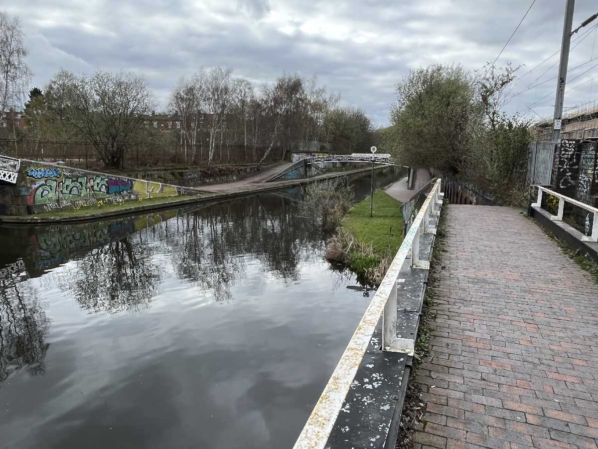
Pass the Arena, and turn left past the Legoland Discovery Centre Birmingham, head down the towpath onto the Birmingham Canal Navigations New Mainline.

Utilita Arena Birmingham - Old Turn Junction

dndimg alt="BCN New Mainline" dndsrc="../uploadedfiles/62889DEF-1C05-4A98-AC0A-D6B372E38022.jpeg" style="width: 100%;" />


At Old Turn Junction is also the start of the Oozells Street Loop at this bridge near Brindleyplace. Part of the Old Mainline.

Oozells Street Loop Junction Bridge - Old Turn Junction

dndimg alt="BCN New Mainline" dndsrc="../uploadedfiles/BCB30681-6E4E-4782-A0BD-2D8676680028.jpeg" style="width: 100%;" />


Walk under the Sheepcote Street Bridge as you pass The Distillery and the Roundhouse.

Sheepcote Street Bridge

dndimg alt="BCN New Mainline" dndsrc="../uploadedfiles/38978DFE-122E-4C61-8F12-E55BA8B7C740.jpeg" style="width: 100%;" />


The Distillery

dndimg alt="BCN New Mainline" dndsrc="../uploadedfiles/06CE760E-67D5-49F2-A305-F22E7F2FBB5C.jpeg" style="width: 100%;" />


The Roundhouse

dndimg alt="BCN New Mainline" dndsrc="../uploadedfiles/A1BE3658-9063-4A22-96BD-4AE1478E7ABE.jpeg" style="width: 100%;" />


Before leaving the City Centre you pass Ladywood Junction, where the end of the Oozells Street Loop joins onto the BCN New Mainline.

Ladywood Junction Bridge - Oozells Street Loop

dndimg alt="BCN New Mainline" dndsrc="../uploadedfiles/ED9D9DAB-07B2-442A-A1BB-8F8C8B477B69.jpeg" style="width: 100%;" />


Head out of the City Centre under the St Vincent Street Bridge into Ladywood.

St Vincent Street Bridge

dndimg alt="BCN New Mainline" dndsrc="../uploadedfiles/8E6672DF-CE05-4993-A1FB-614AF0F3FA21.jpeg" style="width: 100%;" />


After passing under Ladywood Middleway, at the Monument Road Bridge, you will pass the start of the Ickield Port Loop at Sandy Turn. There is also the Monument Road Basin Bridge, also called Monument Lane Basin, just before Ladywood Middleway.

Sandy Turn bridge - Icknield Port Loop

dndimg alt="BCN New Mainline" dndsrc="../uploadedfiles/2F87B3F1-D7E0-4606-88DF-DB121D162F4C.jpeg" style="width: 100%;" />


The new Port Loop development is between both ends of the Icknield Port Loop near Rotton Park Street.

Port Loop development

dndimg alt="BCN New Mainline" dndsrc="../uploadedfiles/3BA4AE43-4B33-45BB-959E-5046D7775824.jpeg" style="width: 100%;" />


The other end of the Icknield Port Loop is at Rotton Park Junction.

Rotton Park Junction Bridge - Icknield Port Loop

dndimg alt="BCN New Mainline" dndsrc="../uploadedfiles/158C45A2-7DDD-4B16-A8C6-1EFD083BD132.jpeg" style="width: 100%;" />


You will pass over the Eyre Street Junction Bridge, which is at the start of the Soho Loop, near the Soho Wharf development. The other end of the Icknield Port Loop is opposite here, plus the railway bridge that carries the line from Birmingham New Street to Wolverhampton.

Eyre Street Junction Bridge - Soho Loop 

dndimg alt="BCN New Mainline" dndsrc="../uploadedfiles/411F97E0-DA67-484C-B6C7-5AF0BCF4B68E.jpeg" style="width: 100%;" />


Pass under the Rotton Park Towpath Bridge, continue past the Site of Harborne Branch Railway Bridge, until you get to the Lee Bridge.

Lee Bridge

dndimg alt="BCN New Mainline" dndsrc="../uploadedfiles/1AD5C0B3-377A-4ADE-A96F-73C7D2ABFEFC.jpeg" style="width: 100%;" />


Continue up to the Winson Green Bridge, which has Winson Green Road crossing overhead.

Winson Green Bridge

dndimg alt="BCN New Mainline" dndsrc="../uploadedfiles/AEAED132-C15B-4FDC-894B-17006BC40A3E.jpeg" style="width: 100%;" />


The other end of the Soho Loop is at Winson Green Junction. This is near the Soho EMU Depot, home of the Cross City Line's famous Class 323 Electric Multiple Units!

Winson Green Junction Bridge - Soho Loop

dndimg alt="BCN New Mainline" dndsrc="../uploadedfiles/6057678A-E77E-4C4E-9969-84682F853ABE.jpeg" style="width: 100%;" />


The Winson Green Gauging Island is next to the Winson Green Roving Bridge, as you pass the Soho EMU Depot (either side of the canal, there is a towpath on both sides here).

Winson Green Roving Bridge

dndimg alt="BCN New Mainline" dndsrc="../uploadedfiles/66B79FC5-218A-4AEE-8CB9-2D532CED4AC0.jpeg" style="width: 100%;" />


Continue walking up to the railway bridge, as you will soon cross into Smethwick in Sandwell.

Soho Railway Bridge

dndimg alt="BCN New Mainline" dndsrc="../uploadedfiles/DCC83FB1-4CCD-43D3-ADAF-EB869AA88010.jpeg" style="width: 100%;" />


Between here was the site of Soho Foundry Basin, and the site of Smethwick Gas Works Basin, and the French Walls Basin Bridge.

Rabone Lane Bridge

dndimg alt="BCN New Mainline" dndsrc="../uploadedfiles/C9106B94-B902-43AF-8439-F7E6B0DDFB01.jpeg" style="width: 100%;" />


Smethwick Junction on the BCN is where the New Line and Old Line splits. The New Mainline is to the left on the Birmingham Level, while the Old Mainline is to the right on the Wolverhampton Level.

Smethwick Main Line Turnover Bridge - Smethwick Junction

dndimg alt="BCN New Mainline" dndsrc="../uploadedfiles/4619F0A4-36A9-4348-B1F9-F255DE2C91EF.jpeg" style="width: 100%;" />


The Rolfe Bridge in Smethwick is at Bridge Street North. One of the towpaths is fenced off here.

Rolfe Bridge

dndimg alt="BCN New Mainline" dndsrc="../uploadedfiles/F6B7ACF3-4813-4C78-8784-1969834F6984.jpeg" style="width: 100%;" />


Passing the Rolfe Pipe Bridge and Smethwick Stop, and then pass under the Engine Arm Aqueduct.

Engine Arm Aqueduct

dndimg alt="BCN New Mainline" dndsrc="../uploadedfiles/C2243D55-D83A-43D2-8178-8940B0B2D0D3.jpeg" style="width: 100%;" />


The next bridge to walk under is the Brass House Bridge, which is on Brasshouse Lane in Smethwick.

Brass House Bridge

dndimg alt="BCN New Mainline" dndsrc="../uploadedfiles/B4A1CF64-16A1-42D0-BEDF-6DE489414E18.jpeg" style="width: 100%;" />


The Smethwick Pumping Station, also called the Galton Valley Canal Museum, or the New Smethwick Pumping Station. It was built in 1892. The lower level is on the New Mainline, while the upper level to the right is on the Old Mainline of the BCN.

Smethwick Pumping Station

dndimg alt="BCN New Mainline" dndsrc="../uploadedfiles/A8D3A1EF-949C-4479-AD4D-696DC0525FFC.jpeg" style="width: 100%;" />


Walking up to the Galton Tunnel from the southeastern portal, then walk through to the northwestern portal. It was built of concrete, and is below Telford Way.

Galton Tunnel

dndimg alt="BCN New Mainline" dndsrc="../uploadedfiles/466CD1E7-9C08-475D-BAFB-35CA2ED83544.jpeg" style="width: 100%;" />


Cross under the famous Galton Bridge. Opened in 1829 and designed by Thomas Telford. It has been pedestrianised since the 1970s. A Grade I listed structure.

Galton Bridge

dndimg alt="BCN New Mainline" dndsrc="../uploadedfiles/DD55CD1E-E29F-4895-9719-78BE1443E673.jpeg" style="width: 100%;" />


The next bridge is the Smethwick Railway Bridge. This was converted into Smethwick Galton Bridge Station in 1995, with the opening of the Jewellery Line, it carries the Snow Hill lines on the high level, while there is also a low level that carries the line from Birmingham New Street to Wolverhampton.

Smethwick Galton Bridge Station

dndimg alt="BCN New Mainline" dndsrc="../uploadedfiles/8A7757F9-E149-4572-8565-1A8BD327439F.jpeg" style="width: 100%;" />


The next bridge carries Spon Lane South, not far from the remains of the Chance Glassworks.

Spon Lane Station Bridge 

dndimg alt="BCN New Mainline" dndsrc="../uploadedfiles/CB933BAF-1992-45C2-902F-8BF868D71D3F.jpeg" style="width: 100%;" />


This was where Jonathan ended his walk, and turned back towards Birmingham. Beyond here is a couple of bridges next to Chance Glassworks, and Spon Lane Junction, where the Old Mainline crossed the New Mainline on the Steward Aqueduct, followed by the M5 motorway.


You can either walk or cycle back, or leave at Spon Lane South, and walk to Smethwick Galton Bridge Station, to catch the train to either Birmingham Snow Hill or Birmingham New Street (your choice, remember to buy your train tickets before travelling). Also various nearby bus routes.


Post by Elliott Brown. Photos from Jonathan Bostock.

Share  Spend Points  Connect with us
80 passion points
Show more